Why Agricultural Drone Solutions Are Reshaping UK Farm Work
@f76u5pkr2c
October 8, 2026 · 9 min read
From Boots on the Ground to Eyes in the Sky
I remember walking a 40-acre winter wheat field with a clipboard, a soil probe, and a growing sense that I was missing something. The crop looked uniform from the gate, but by the time I reached the far corner, it was clear the headland was struggling while the middle was thriving. That sort of variability is normal, but spotting it early used to take hours. Now, with agricultural drone solutions, that same field can be mapped in minutes, and the differences become obvious before they cost you a tonne of yield.
The shift is not just about seeing more. It is about acting differently. Drones have moved from a novelty to a practical tool on many UK farms, and the range of tasks they can handle keeps expanding. Whether you are spreading seed into a cover crop, spraying a late blight spot in potatoes, or simply checking whether the drainage work actually fixed that wet patch, there is a drone application that fits. And the technology is not standing still.
What a Modern Ag Drone Actually Does
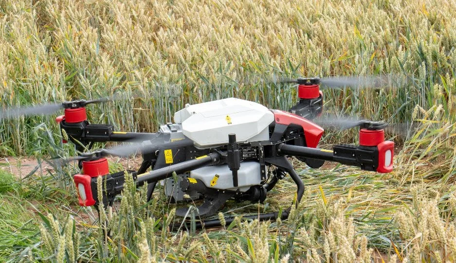
If your only image of a drone is a small quadcopter hovering over a garden, think bigger. The machines used in agriculture now carry serious payloads. The DJI Agras series, for example, can hold 30 to 50 litres of liquid or up to 50 kilograms of granular material. That is not a toy. It is a working implement that can cover ten to fifteen hectares an hour for spraying, depending on conditions and settings.
Spreading and spraying are the two main jobs. For spreading, you can put out fertiliser, slug pellets, or even cover crop seed. The advantage over a tractor is not just speed. A drone flies low and slow enough to place material precisely where you want it, and it does not compact the soil. After a wet winter, getting on the land early with a heavy spreader can do more harm than good. A drone does not leave a wheel mark.
Spraying is where the precision really shows. Instead of blanketing a whole field, you can target a specific zone that needs treatment. That is the idea behind variable rate application, and drones make it practical. You can load a prescription map into the flight controller, and the drone adjusts its output on the fly. Less chemical, less cost, and less drift into neighbouring fields or watercourses. That matters when you are dealing with crop protection products that need careful handling.
Mapping and Scouting: The Quiet Workhorse
Not every drone job ends with something being applied. Much of the value comes from what you learn before you act. A drone equipped with a multispectral camera can capture NDVI imagery, which shows plant health by measuring how leaves reflect light. Stressed areas show up as a different colour long before they are visible to the eye. That allows you to walk a specific spot, take a soil sample, or check for pests rather than walking the whole field.
Crop scouting with a drone is faster and more thorough than the old method of walking a W pattern across the field. You can cover forty acres in ten minutes, and the images are georeferenced, so you know exactly where that patch of thistles is. Some platforms, like SenseFly and Parrot, have made this kind of mapping very accessible, with software that stitches images into a single field map that you can open on your phone or tablet.
This is not just about convenience. It is about making better decisions. When you can see the variability in a field, you can adjust your seeding rate, your nitrogen plan, or your spray timing. That is precision agriculture in its most practical form. And when you combine NDVI maps with soil data and yield history, you start to build a picture of the farm that no amount of walking will give you.
The Practical Side: Rules, Training, and Costs
There is a common misconception that anyone can buy a drone and start spraying. In the UK, that is not the case. The Civil Aviation Authority, or CAA, regulates all drone use, and agricultural operations fall under specific rules. If you are flying for work, you need to be a qualified pilot or employ one. For spraying, there are additional requirements around the type of drone, the operator, and the way the work is done. The National Farmers' Union has published guidance, and it is worth reading before you commit.
Getting the required permissions is not just a formality. It is about safety and accountability. A 30 kg drone carrying a tank of pesticide is a serious piece of machinery. It can cause damage if it fails, and spray drift can affect people, animals, and crops on neighbouring land. That is why the CAA and the Health and Safety Executive have their eyes on this sector. The good news is that the industry has responded with robust training and certification programmes.
Cost is another factor. A professional agricultural drone, such as the DJI Agras T40 or a similar model from XAG, can cost anywhere from £15,000 to £30,000 or more, depending on the configuration and the accessories. On top of that, you need RTK GPS for centimetre-level accuracy, which usually involves a base station or a subscription to a network. Then there are batteries, chargers, a maintenance kit, and the cost of the training and permissions. It adds up.
But you do not have to buy one outright. Many farmers start by hiring a contractor for a specific job, such as a late-season fungicide application on wheat or a targeted slug pellet spread on oilseed rape. That way, you can see how the technology performs on your land before you invest. Some agronomy firms now offer drone services as part of their package, and the availability is growing.
Real-World Examples and Trade-Offs
Take the case of a dairy farm in Cheshire that used a drone to spread cover crop seed into standing maize stubble in early September. The goal was to establish a rye and vetch mix before the winter, without disturbing the soil. A tractor-drawn drill would have needed a separate pass, and the ground was still firm enough, but the drone did the job in a single afternoon. The seed went on evenly, and the establishment was good, even in the headlands that often get missed.
Another example is a potato grower in East Anglia who used drone spraying to control blight late in the season. The crop was too tall for a tractor sprayer without damaging the foliage, and the ground was too wet for heavy equipment. A drone, flying just above the canopy, managed the job with less risk of compaction and no crop damage. The grower said it was the difference between saving a portion of the crop and losing most of it.
But there are trade-offs. Drones have a limited flight time, usually 10 to 20 minutes per battery, depending on the model and the payload. That means you need spare batteries and a system for swapping them quickly. For very large fields, you might need multiple drones or a ground crew to keep up. Weather is also a factor. High winds, rain, and even very bright sunlight can affect flight quality and the accuracy of the application. You have to pick your windows carefully.
There is also the question of data management. A drone can generate a huge amount of imagery, and it is easy to end up with a hard drive full of maps that you never look at again. The value comes from making decisions based on what the data shows, not from collecting it for its own sake. That is where a good agronomist or a trusted service provider becomes essential. They can interpret the imagery and turn it into a practical recommendation.
The Role of Big Names and New Entrants
When people talk about agricultural drone solutions, the names that come up most often are DJI Agras, XAG, and the older but still relevant Yamaha Motor. Yamaha has been making agricultural helicopters since the 1980s, and their experience shows in the reliability of their systems. DJI Agras has become a market leader for spraying and spreading, with a wide range of models and a growing support network. XAG is pushing the boundaries with autonomous ground vehicles and drones working together, which is an interesting future to watch.
SenseFly and Parrot are more focused on mapping and scouting, and their fixed-wing and multirotor platforms are popular with agronomists and surveyors. These are not the machines that apply inputs, but they are the ones that tell you where to apply them. The combination of a mapping drone and a spraying drone is a powerful one. You map the field, create a prescription, and then send in the applicator with pinpoint accuracy.
In the UK, the adoption has been slower than in some other countries, partly because of the regulatory hurdles and partly because of the cost. But the interest is definitely there. The National Farmers' Union has highlighted the potential of drones to help with the transition to more sustainable farming, and the CAA is working on a framework that will make it easier for farmers to operate within the rules. It is a matter of time before this becomes a standard tool, like a telehandler or a yield monitor.
Looking Ahead: Where the Technology Is Going
The next few years will bring better battery life, lighter materials, and more intelligent software. Some systems are already using artificial intelligence to identify weeds or pests in real time, and that will only improve. The challenge will be integrating all this data into the daily decisions on the farm. It is not about replacing the farmer's judgement, but about giving it more to work with.
For anyone considering whether agricultural drone solutions are right for their farm, my advice is to start small. Rent a drone for a scouting flight, or hire a contractor for a single spraying job. See how the data looks on your own fields. Talk to other farmers who have used it. Ask your agronomist what they think. The technology is not a magic bullet, but when used well, it can save time, reduce costs, and improve the accuracy of your operations. And that is a trade worth making.